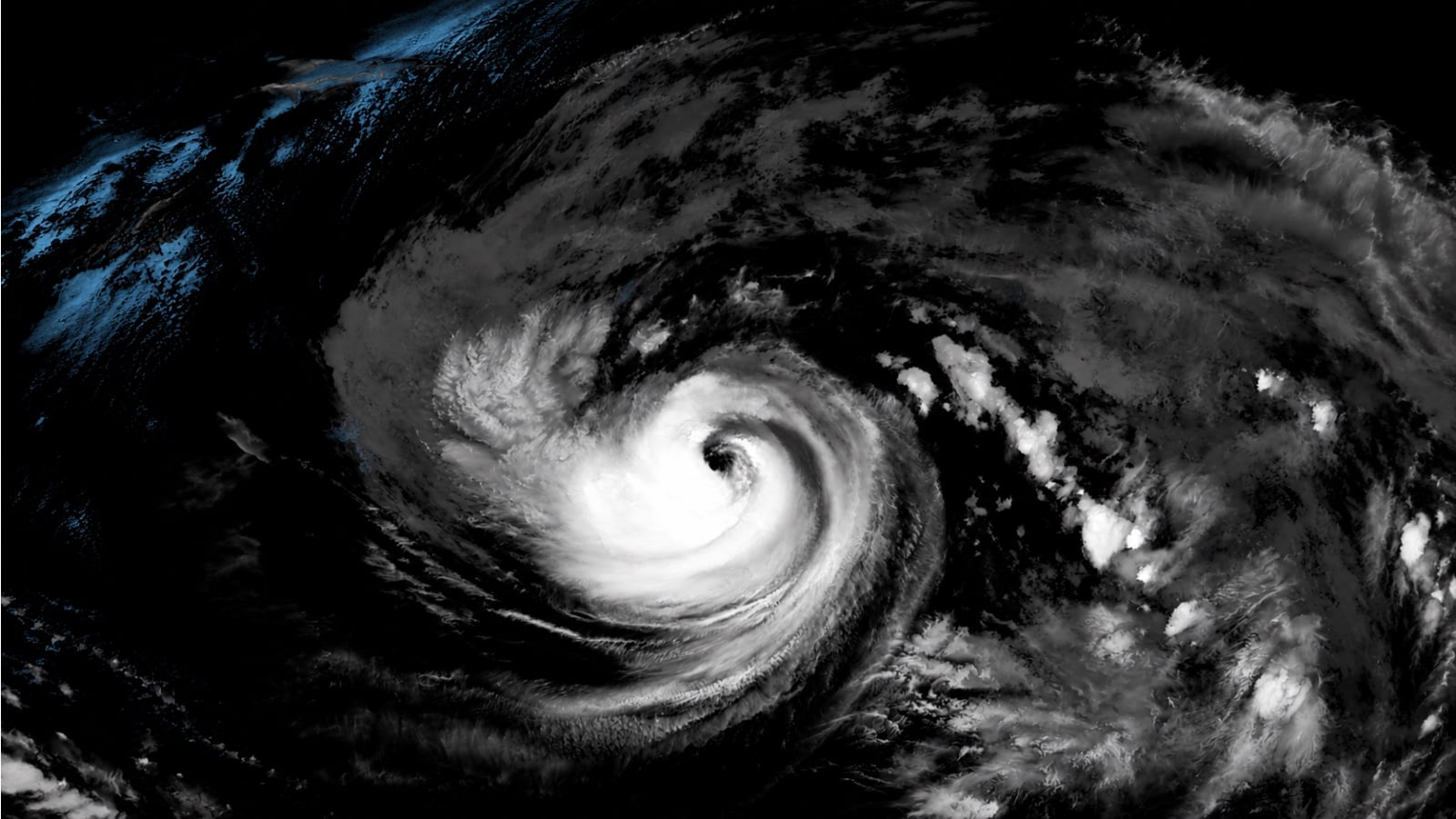
Hurricane Karina is currently churning across the open waters of the Eastern Pacific, approximately 820 miles southwest of the southern tip of Baja California, packing sustained winds of 80 miles per hour.
The system poses no immediate threat to land. Yet, meteorologists tracking its trajectory anticipate rapid intensification over the coming days, driven by favorable sea surface temperatures and low vertical wind shear. While coastal communities from Mexico to Southern California will escape a direct strike, they will experience heavy swells, dangerous surf, and persistent rip currents. Karina transitioned from a modest tropical storm into a Category 1 hurricane faster than initial computer models predicted, once again exposing the persistent blind spots forecasters face when monitoring open-ocean rapid intensification cycles.
Satellites capture the cloud tops, but the true mechanical engine of a hurricane operates below the surface layer. Understanding how a storm like Karina transitions from a disorganized cluster of thunderstorms into a major hurricane requires looking past basic wind speed charts and examining the thermodynamic feedback loops unique to the Eastern Pacific.
The Thermodynamic Fuel Tank
Warm water acts as the primary battery for any tropical cyclone. The Eastern Pacific basin possesses a distinct advantage that frequently catches casual observers off guard: deep layers of high-heat-content water extending well away from the immediate coastline.
As Karina tracks northwest at roughly 15 miles per hour, it traverses an ocean highway characterized by elevated sea surface temperatures. When surface waters exceed 26.5 degrees Celsius, evaporation accelerates. Warm, moisture-laden air rises rapidly, creating a low-pressure vacuum at the surface. As that air ascends, it cools and condenses, releasing latent heat into the core of the storm.
That released heat is the currency of intensification.
The environment surrounding Karina provides minimal atmospheric friction or wind shear to disrupt the vertical column of the storm. Without shear tearing the thunderstorm tops away from the low-level center, the storm maintains a symmetric, upright structure. This structural integrity allows the internal pressure to drop sharply. Lower pressure draws in surrounding air faster, which increases surface wind speeds, which in turn churns up more moisture. It is a closed, self-reinforcing cycle.
[Warm Ocean Water (>26.5°C)]
       │
       ▼
[Rapid Evaporation & Moisture Rise]
       │
       ▼
[Latent Heat Release in Core]
       │
       ▼
[Surface Pressure Drops & Winds Accelerate]
Forecasting the Unseen Shift
Predicting when a storm will cross the threshold into major hurricane status—defined as Category 3 or higher with winds exceeding 111 miles per hour—remains one of the most stubborn challenges in modern meteorology.
Numerical weather prediction models often struggle with the microphysics occurring inside the eyewall. While satellite scatterometers measure surface winds from space, they provide snapshots rather than continuous streams of data. Hurricane Hunter aircraft operated by the National Oceanic and Atmospheric Administration routinely fly directly into Atlantic and Caribbean systems to drop sondes that measure pressure, temperature, and humidity profiles from the inside out.
However, storms in the open Eastern Pacific like Karina frequently sit beyond the safe operational range of routine reconnaissance flights until they edge closer to populated landmasses or vital shipping lanes. Forecasters must rely heavily on satellite extrapolation and advanced computer algorithms.
When a system undergoes rapid intensification—defined as an increase in maximum sustained winds of at least 35 miles per hour in a 24-hour period—the margins for error vanish. Karina's current trajectory takes it over increasingly isolated waters, meaning fewer direct atmospheric measurements will be available to verify its internal structural changes. Meteorologists are left watching infrared satellite loops for the telltale sign of a tightening eye, inferring intensity changes from cloud-top temperatures rather than direct barometric pressure readings.
The Ripple Effect Across the Basin
Even when a hurricane stays hundreds of miles offshore, its physical footprint extends far beyond the gale-force wind radius. The sheer energy displaced by a mature cyclone transforms into long-period ocean swells that radiate outward across thousands of miles of open ocean.
For the coastline of Baja California and sections of mainland Mexico, Karina's presence manifests primarily through maritime hazards.
- Coastal Swells: Deep-water waves generated by intense core winds propagate outward, arriving at distant shores days before the storm reaches peak intensity.
- Rip Currents: Complex wave interference patterns create hazardous swimming conditions, catching beachgoers unaware on otherwise calm sunny days.
- Shipping Lanes: Commercial vessels traversing the Eastern Pacific must reroute to avoid high seas and structural crosswinds associated with the outer bands.
Simultaneously, a companion system, Tropical Storm Lowell, churns further west in the basin. While Lowell poses no immediate threat to Hawaii or North America, its simultaneous formation alongside Karina highlights a broader seasonal rhythm. El Niño and La Niña oscillations alter the large-scale atmospheric pressure patterns, steering moisture convergence zones and dictating how many storms ignite across the northern hemisphere's tropical basins.
The current season demonstrates how a warm Pacific basin can sustain multiple simultaneous spinning engines, each feeding on localized patches of high oceanic heat content. Karina will eventually encounter cooler waters further north and west, causing the system to lose its tropical characteristics and dissipate into an open-ocean remnant low. Until that transition occurs, tracking its hourly wobble remains a high-stakes exercise in interpreting subtle shifts in cloud patterns over a vast, indifferent ocean.