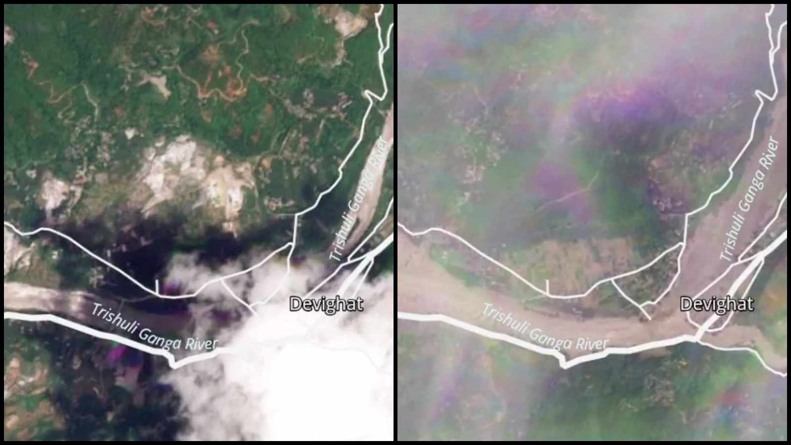
High-altitude orbiters do not panic. They simply record the quiet erasure of geography. Recent orbital telemetry over the Nepal-Tibet border reveals a terrifying geologic shift: entire green mountainsides transformed into monochromatic fields of pulverized stone and grey mud.
When the flash floods tore down the Bhote Koshi and Trishuli river valleys, initial reports pointed toward tectonic violence. Global monitoring networks registered a seismic signature, leading many to believe an earthquake had rattled the roof of the world. That assumption was dead wrong. Subsequent analysis of high-resolution optical and radar data from platforms like Planet Labs and ISRO's Resourcesat confirmed a far more insidious mechanism: a massive high-altitude glacial detachment.
A significant portion of a glacier perched at roughly 5,200 meters sheared off from the rock face, plunging more than a thousand meters onto the valley floor below. The resulting ice-rock avalanche generated enough energy to mimic a magnitude 5.2 earthquake, sending an incomprehensible wall of water, sediment, and boulders tearing through downstream communities.
The Anatomy of a High-Altitude Catastrophe
To understand how a frozen slab miles above civilization can obliterate multi-story buildings fifty miles away, one must look at the physics of debris flows. When an ice mass detaches at terminal velocity, it does not merely slide. It shatters, liquefies, and entrains millions of tons of loose scree, moraine deposits, and topsoil.
Ground zero was located near the Lhende River in the Rasuwa district. Eyewitness accounts and subsequent drone footage describe a sudden, suffocating roar followed instantly by a wall of grey sludge that climbed up to thirty feet high in a matter of minutes. Houses built to withstand mountain winters folded like cheap cardboard. Hydropower installations, vital economic lifelines for the region, were smashed into twisted scrap metal before operators could trigger emergency shutdowns.
Satellites recorded the aftermath with clinical precision. Pre-disaster frames show dense vegetation and meandering alpine streams. Post-disaster captures reveal river channels bloated to three times their normal width, choked with sedimentary blankets that have entirely rewritten local topography.
The Thermal Fingerprint Hidden in Plain Sight
Geologists poring over orbital records noticed a critical precursor that predated the roar of the avalanche. Hours before the collapse, comparison frames showed a sharp, anomalous reduction in snow cover across adjacent high-altitude basins. Expanses that were locked in white forty-eight hours prior were reduced to bare, exposed ice.
This sudden transition points directly to thermal stress. The Hindu Kush Himalaya region is warming at a rate well above the global average. Glaciers across this corridor are not simply shrinking; they are rotting from the inside out. Meltwater penetrates deep crevasses, pooling at the base of the ice shelf and creating hydraulic pressure that acts like a crowbar. When internal temperatures spike, friction vanishes. The glacier lets go.
Yet, institutional readiness remains anchored to twentieth-century models of disaster response. Governments spend millions reinforcing riverbanks against standard monsoon surges while ignoring the upper atmospheric triggers happening leagues above human settlements. River gauge sensors lower in the valley are completely useless when the disaster originates five thousand meters up in a zone devoid of telecommunication infrastructure.
The Cost of Living in the Shadow of Thawing Ice
The human toll of this geographic reconfiguration is staggering. Scores of lives lost, hundreds missing, and entire families erased from village registries. Rescue helicopters have found themselves grounded by the sheer impenetrability of the new landscape, unable to land in choked valleys where roads once ran.
We treat these events as isolated anomalies, tragic aberrations of nature to be met with temporary aid packages and ministerial condolences. They are nothing of the sort. They are recurring symptoms of an atmospheric debt coming due. Every degree Celsius of warming adds another unstable dagger of ice to the precipices above South Asia's most densely populated river basins.
Orbital imagery gives us a window into the destruction, but looking at photographs of a wound after the bleeding has stopped does nothing to stanch the flow. Until hazard mitigation moves past the riverbanks and begins monitoring the high glacial crowns where these disasters are quietly incubating, satellite maps will remain simple archives of preventable loss.