The Thermodynamics of Wildfire Propagation
Wildfire acceleration during a heatwave is not a linear degradation of environmental conditions; it is a compound thermal feedback loop. When ambient temperatures cross critical operational thresholds, suppression efforts fail because the physics of fire behavior outpace human resource deployment capacity. Understanding fire propagation in central Spain requires breaking down the core mechanisms that drive ignition speed, flame length, and atmospheric destabilization.
Wildfire spread operates through three primary energy transfer mechanisms: conduction, convection, and radiation. During prolonged atmospheric heat domes, radiation and convection dominate the system landscape.
[Elevated Atmospheric Temperature] + [Suppressed Relative Humidity]
                       │
                       ▼
      [Fuel Moisture Depletion (<6% Threshold)]
                       │
                       ▼
   [Convective Heat Transfer Acceleration] ──► [Spotting & Flame Front Advance]
1. Fuel Pre-Heating and Moisture Kinetics
Vegetation acts as a thermal sponge. As ambient temperatures rise toward 40°C and relative humidity drops below 15%, fine fuels—such as dry grasses, leaf litter, and low-lying brush—lose internal moisture at an exponential rate. When fuel moisture content drops below 6%, the energy required to vaporize internal water drops to zero. Consequently, every unit of thermal energy emitted by the advancing fire front transfers directly into igniting adjacent vegetation rather than boiling off residual water.
2. Convective Plume Dynamics
As large fire fronts expand, the localized thermal output creates an extreme updraft of hot air, drawing in cooler surrounding air to feed the combustion zone. In topographically complex regions like central Spain's interior mountain corridors, these convective plumes generate localized wind fields that operate independently of regional weather patterns. These fire-induced winds transport burning embers kilometers ahead of the main fire front—a phenomenon known as spotting—bypassing physical containment lines entirely.
3. Atmospheric Boundary Layer Collapse
Heatwaves are driven by high-pressure atmospheric systems that trap air near the surface, suppressing vertical movement. As the surface air reaches extreme temperatures, the lower atmosphere becomes hyper-unstable. When a massive wildfire injects thermal mass into this unstable layer, it triggers Pyrocumulonimbus (PyrCu) formations. These fire-generated storm clouds produce severe downdrafts and erratic lightning, expanding the ignition surface area unpredictable distances from the primary perimeter.
The Operational Bottleneck of Wildfire Suppression
Resource allocation in wildland firefighting is governed by the rate of line construction versus the rate of fire perimeter growth. Suppression tactics fall into three categories: direct attack, indirect attack, and parallel containment. Extreme thermal events systematically degrade the efficacy of each operational pillar.
The Direct Attack Threshold
Direct attack involves crews applying water, retardant, or handtools directly at the burning edge of the fire. The physical limit for direct attack by ground personnel is a flame length of 1.5 meters. Beyond 1.5 meters, thermal radiation poses an immediate threat to human life, and hand-built containment lines are easily overtopped by radiant heat.
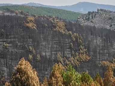
During acute heatwaves, typical flame lengths in Mediterranean pine forests and scrublands regularly exceed 4 to 10 meters. This shifts the operational requirement entirely to indirect attack strategies, forcing incident commanders to abandon the fire perimeter and retreat to natural or artificial barriers.
+---------------------+-----------------------+----------------------------------+
| Flame Length        | Primary Mode          | Operational Efficacy             |
+---------------------+-----------------------+----------------------------------+
| < 1.5 meters        | Direct Attack         | High (Ground crews + Hand lines) |
| 1.5 - 3.5 meters    | Combined Attack       | Moderate (Requires heavy machinery)|
| > 3.5 meters        | Indirect / Aerial     | Low (Suppression limited)        |
+---------------------+-----------------------+----------------------------------+
Aerial Suppression Efficiency Losses
Aerial assets—such as Canadair amphibious water bombers and heavy-lift helicopters—are often cited as the primary countermeasure against large-scale wildfires. However, extreme high temperatures impose physical limitations on aviation performance:
- Density Altitude Limits: High ambient temperatures reduce air density. Low air density decreases wing lift and engine thrust, forcing aircraft to reduce their payload capacity to safely maneuver in mountain terrain.
- Evaporative Yield Loss: When dropping water or chemical retardant from altitudes above 50 meters, extreme surface temperatures cause a significant percentage of the payload to evaporate before hitting the canopy, reducing the effective density of the drop.
- Visibility and Convective Turbulence: Thermal updrafts within fire zones generate violent turbulence that limits the minimum altitude at which pilots can operate safely, decreasing drop accuracy.
Systemic Vulnerabilities in Mediterranean Ecosystems
Central Spain presents a specific set of structural and ecological vulnerabilities that amplify the impact of atmospheric thermal events. Evaluating these factors requires looking beyond immediate weather anomalies to long-term spatial and socio-economic shifts.
Rural Depopulation and Fuel Accumulation
Over the past five decades, rural-to-urban migration across Spain's interior has led to the abandonment of traditional agricultural practices. Historically, livestock grazing, fuel-wood collection, and controlled agrarian burning maintained low fuel loads across the terrain. The removal of these human-managed disturbances has resulted in vegetation thickening, creating continuous fuel beds that enable high-intensity crown fires.
Topographic Chimney Effects
Central Spain features complex topography characterized by mountain ranges, deep river valleys, and high plateaus. Valleys act as natural chimneys during thermal events. As air within a canyon heats up, it rapidly ascends the slope, drawing the fire upward at speeds that increase exponentially with the incline. A fire moving up a 30-degree slope advances four times faster than a fire on flat terrain due to the preheating of uphill fuels by the tilted flame front.
   /
  /  ◄── Upward Convective Pre-heating
 /       (Fire advances up to 4x faster on 30° slopes)
/
Interfacial Risk Expansion
The expansion of residential infrastructure into wildland environments—the Wildland-Urban Interface (WUI)—fundamentally alters firefighter priority matrices. When a fire threatens residential structures, suppression resources must be diverted from perimeter containment to structure defense. Tactical resources are pulled from offensive operations to defensive positions, allowing the uncontained flanks of the fire to expand unchecked into open terrain.
Tactical Execution and Mitigation Protocols
To mitigate the catastrophic failure of suppression systems during extreme thermal events, fire management authorities must pivot from reactive containment to structural risk reduction.
Strategic Fire Analysis Units
Deploy real-time fire behavior modeling teams using thermal infrared drone mapping and atmospheric sounding data. Incident commanders must calculate the Rate of Spread ($ROS$) and Byram's Fire Line Intensity ($I$) continuously:
$$I = H \cdot w \cdot r$$
Where:
- $H$ = Fuel low heat of combustion ($\text{kJ/kg}$)
- $w$ = Weight of available fuel consumed per unit area ($\text{kg/m}^2$)
- $r$ = Rate of spread ($\text{m/s}$)
When calculated intensity exceeds $2000 \text{ kW/m}$, all direct ground engagement must cease immediately, and operations must transition to long-range barrier creation.
Fuel Interruption Corridors
Systematically construct permanent fuel breaks using low-combustibility vegetation species combined with mechanical mastication along key topographic ridges. These corridors must be designed to a minimum width of three times the expected maximum tree canopy height to prevent crown-to-crown fire transmission under extreme wind conditions.
Pre-Positioning and Operational Thresholds
Establish rigid trigger points for resource pre-positioning based on 3-day forecasted energy release component ($ERC$) indices rather than waiting for active ignitions. When ambient temperatures are projected to exceed historical 95th-percentile norms alongside relative humidity below 12%, heavy machinery and indirect attack teams must be deployed to pre-established anchor points prior to ignition confirmation.
Shift emergency response doctrine to prioritize structure-triage protocols early in the event life-cycle. Buildings that do not meet minimum defensible space requirements (30 meters of cleared fuel perimeter) must be marked as non-defensible to preserve tactical assets for high-probability containment lines.